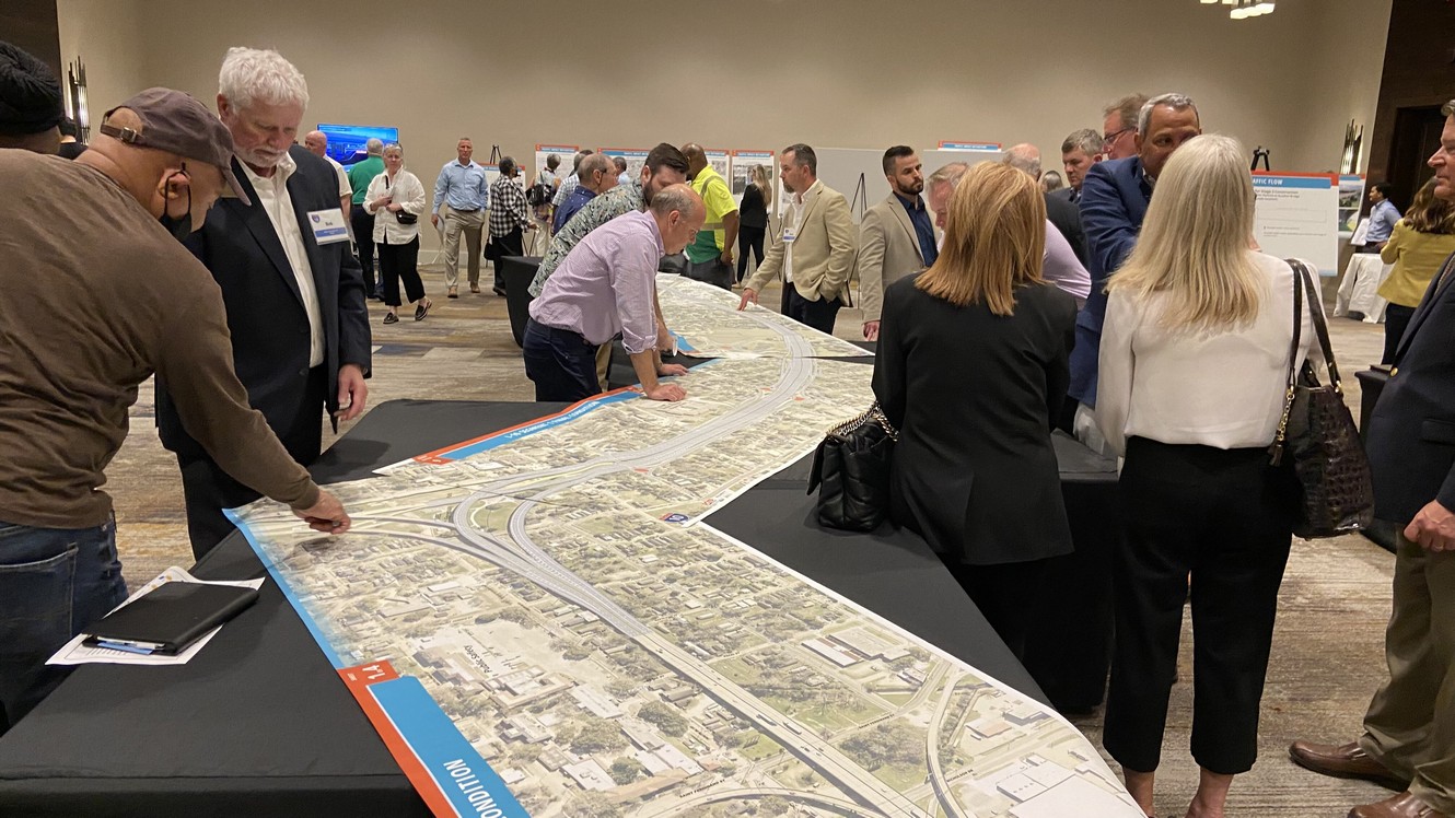
The March 7, 2023 event showcased over 40 exhibits organized into 12 stations, plus an initial video screening room where guests were provided an overview and orientation. The exhibit stations corresponded with project design modifications being submitted to FHWA as part of a reevaluation request to update the Environmental Assessment.
LA DOTD has released responses to a set of public comments and questions received from March 7, 2023 through March 26, 2023. Inquiries and responses may be reviewed in the linked PDF file.
For each image below, clicking on the image will display an enlarged version, and the PDF icon near each offers an opportunity to download a higher resolution, printable version. Some are grouped into sets. Two images below represent videos, and clicking the image plays the video.
Handout
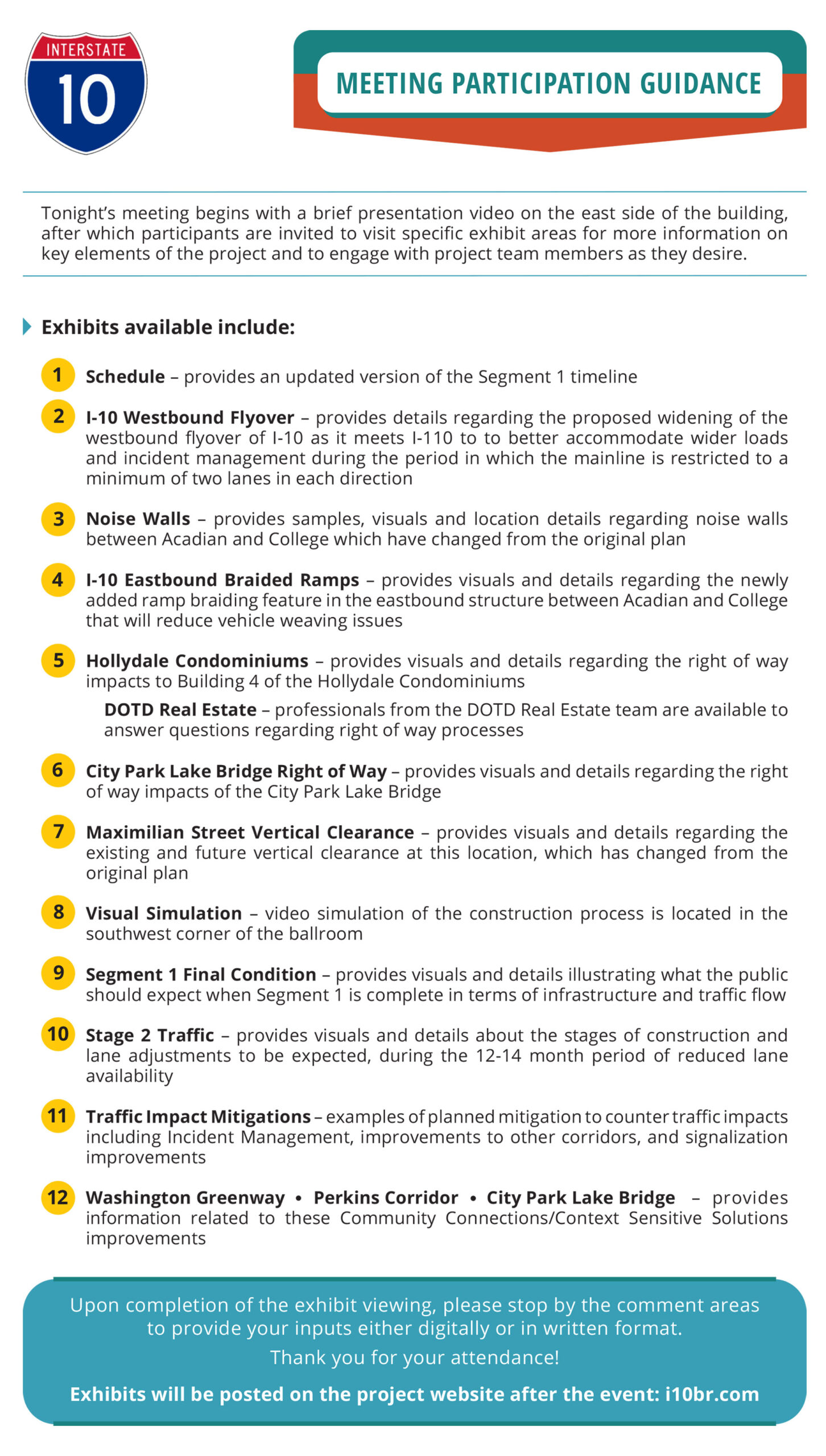
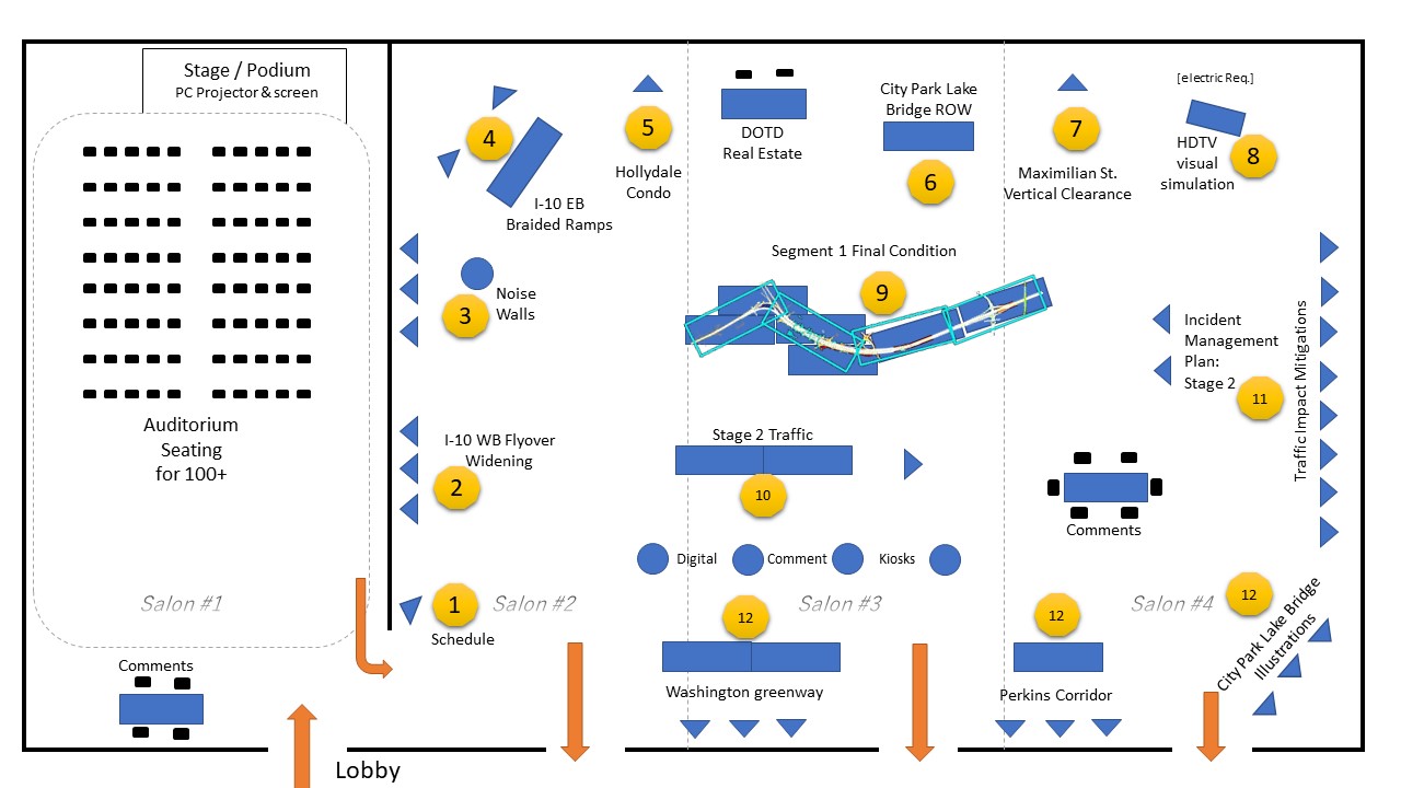
Upon arrival guests were asked to sign-in and were provided a legal size color handout listing the 12 exhibit stations, the reverse side displayed a floorplan of the exhibit hall, and the handout provided notice of the comment submission deadline for inclusion in meeting documentation. [file download]
Layout of Exhibit Stations
Station 0. Meeting Overview Video
The 11-minute video was a narrated slideshow intended to provide a brief project overview and description of the twelve exhibit areas and why they are being presented to the public for comment.
Click to Play
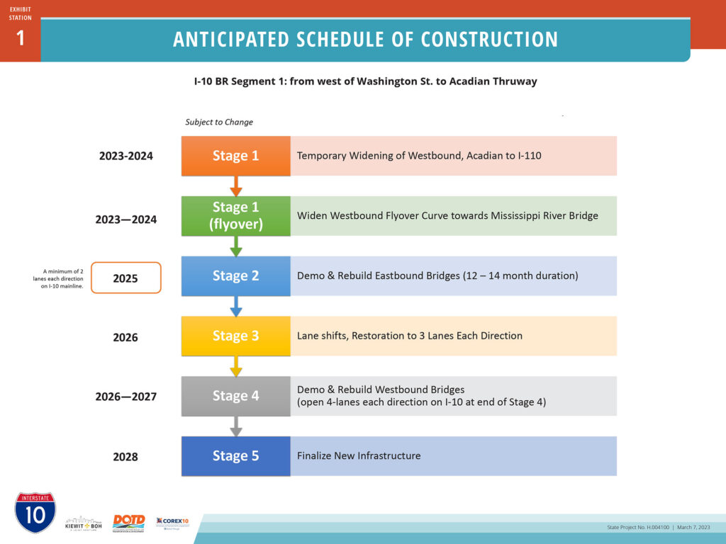
Station 1. Project Schedule Update
The first exhibit board greeting meeting attendees was a graphic schedule of construction for Segment 1. This board illustrated the lengthening of the duration of construction from approximately 4 years to approximately 5 years for Segment 1. This extended duration is to accommodate the widening of the I-10 westbound curve (“flyover”) at I-110 prior to Stage 2 construction. Stage 2 is the period of interstate lane reductions within the project corridor from 3 to 2 in each direction for an anticipated duration of 12 to 14 months beginning in early 2025.
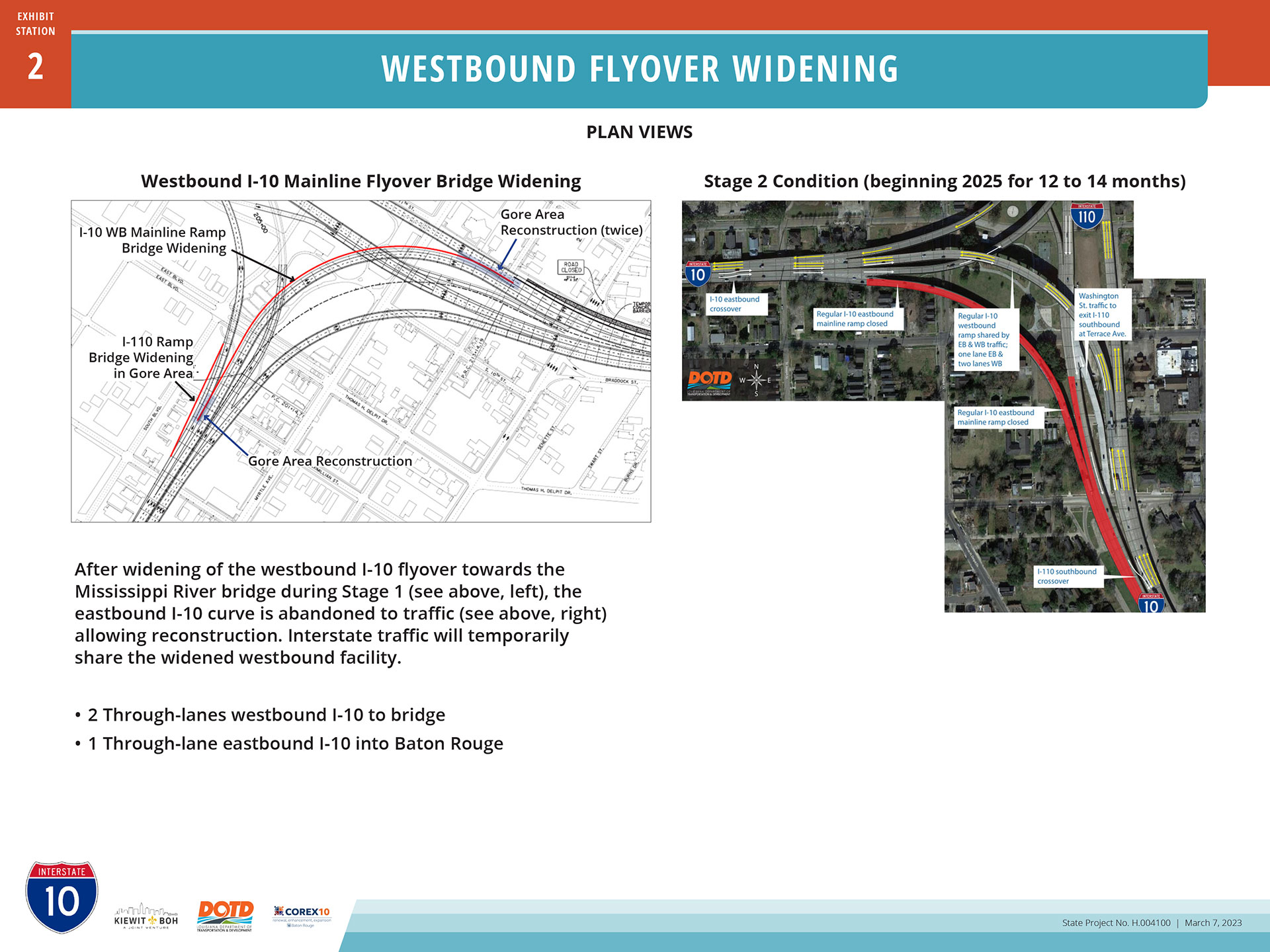
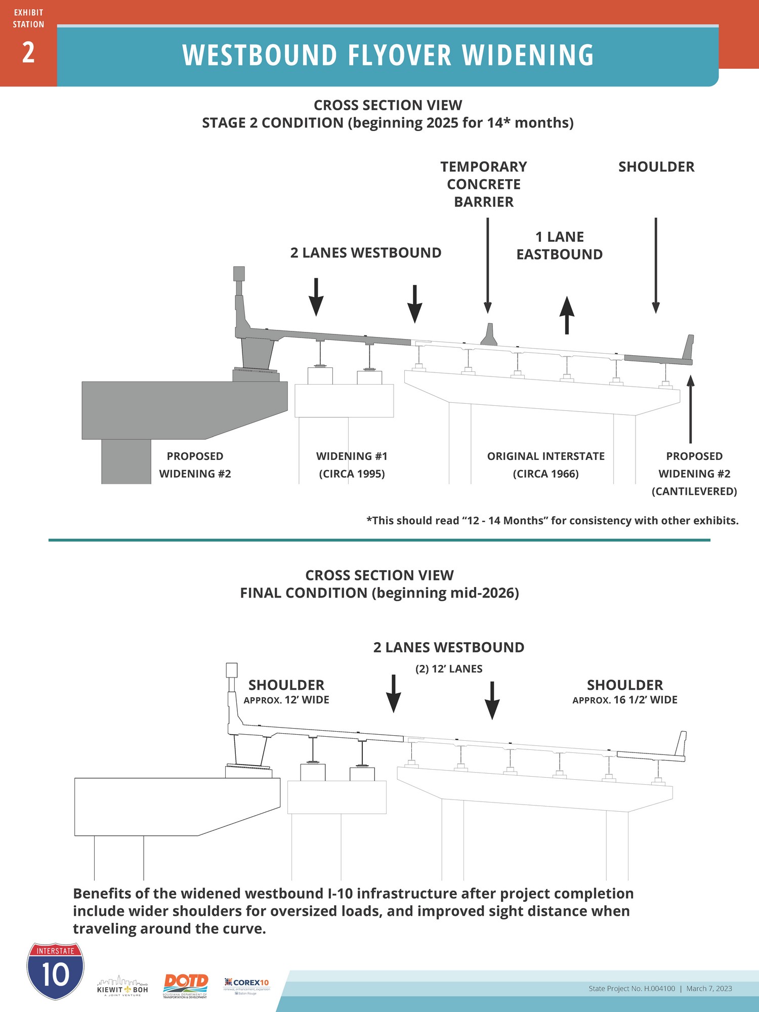
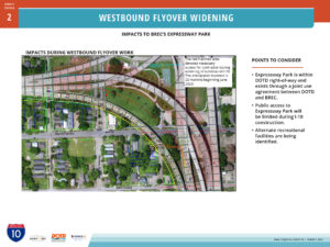
Three exhibits at station 2 describe a proposal for widening the curve of I-10 westbound at I-110 for vehicles traveling towards the Horace Wilkinson Mississippi River Bridge. Initially accommodating 2 westbound travel lanes, this curve was widened during the mid-1990s to install a more robust outside barrier rail. The current proposal would widen this curve yet again, providing room for three travel lanes during construction with shoulders, and the inner and outer barrier rails. During Stage 2 construction, this widened curve will accommodate a total of 3 lanes consisting of two lanes westbound and one lane eastbound, plus shoulders, for the 12 to 14 month duration. A key impetus for this proposal is to accommodate incident management. In the final, completed project condition, two lanes with shoulders and improved sight distances would be provided in the westbound direction.
The widening of this westbound curve of I-10 will cause impacts, both temporary and permanent, to BREC’s Expressway Park lying beneath it. BREC provides this park through a Joint Use Agreement (JUA) with DOTD for the use of DOTD right-of-way. The exhibit below denotes impacts to the park for construction access and new highway infrastructure.
(included with above set)
Station 3. Noise Wall Changes
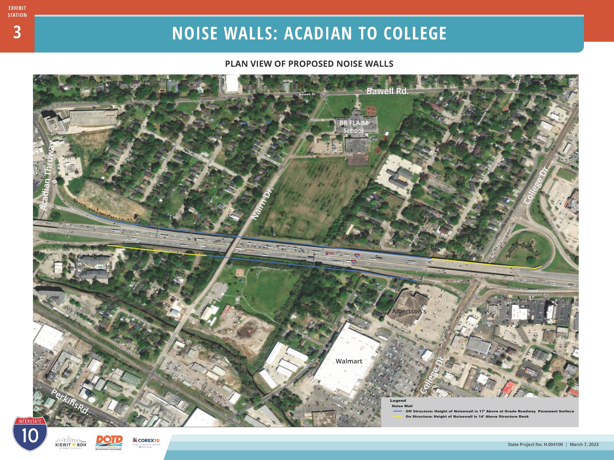
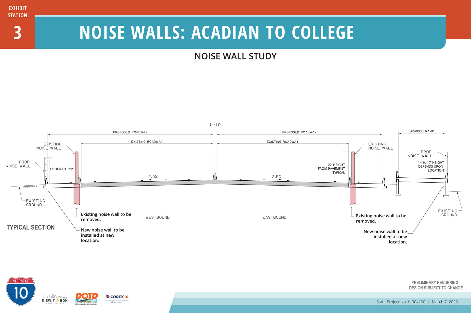
The Environmental Assessment documentation for the project provided instruction for noise walls along the corridor. On the south side of I-10, the inclusion of the Braided Ramp configuration between Acadian Thruway and College Drive on eastbound I-10 (station 4, below) necessitated the replacement of concrete noise walls and installation of crash-tested modular acrylic panel noise walls affixed to interstate concrete barriers. The position, heights, and material of these new walls will differ from current and previously designed solutions. Residents in proximity of these walls – within Baton Rouge’s Valley Park subdivision – were expressly invited to this meeting to learn about this change and provide their feedback. In addition, due to the widening, the concrete noise wall on the north side of I-10 will need to be replaced. The replacement crash tested noise wall will be placed on the concrete barrier rail as shown in the graphic.
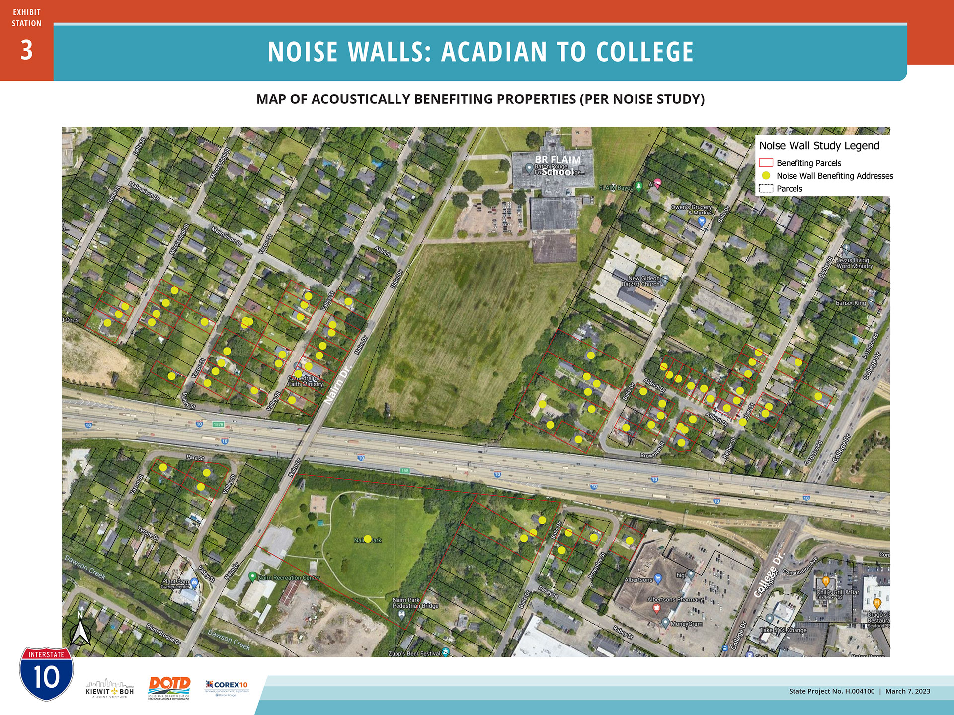
The following map was prepared, but due to a production issue was not available for display at the March 7, 2023 open house. The map locates the addresses of 76 residences identified in the project’s Noise Study Addendum as receiving acoustic benefit from the proposed acrylic noise walls.
(included with above set)
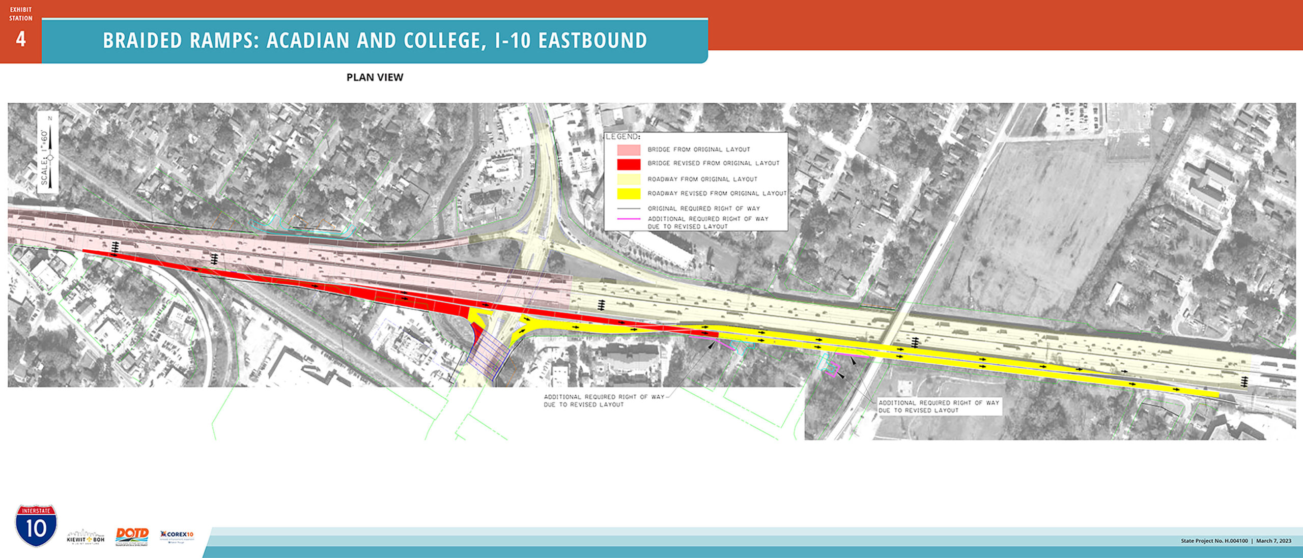
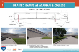
Station 4. Braided Ramps at Acadian and College
Refinements of the final interstate design included a change to eastbound I-10 between Acadian Thruway and College Drive. A braided ramp configuration is proposed here to eliminate the existing traffic weaving conflict, which separates the eastbound traffic entering from Acadian from the I-10 eastbound traffic exiting to College. The proposed entry and exit ramps require real estate acquisition of additional right of way for public use from several contiguous private property owners. Five of six property owners had been briefed of this right-of-way need individually, prior to the public open house.
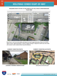
The future widened I-10 eastbound will be positioned closer to building #4 of Hollydale Condominium, located near Perkins Road and Christian Street, than the current interstate. This proximity of new infrastructure has not changed from earlier plans described in the Environmental Assessment (EA) or Finding of No Significant Impact (FONSI) documents. However, property survey has revealed that the actual ROW line is approximately 2 feet off from the earlier assumed ROW line derived from Parish data, and that approximately an additional 2.5 feet of new ROW must be acquired from condominium building #4. Rear fences and portions of concrete patios of these five dwelling units already encroach into DOTD ROW approximately 2 feet, and since an additional approximate 2.5 feet must be acquired, rear patio areas of these units will be reduced.
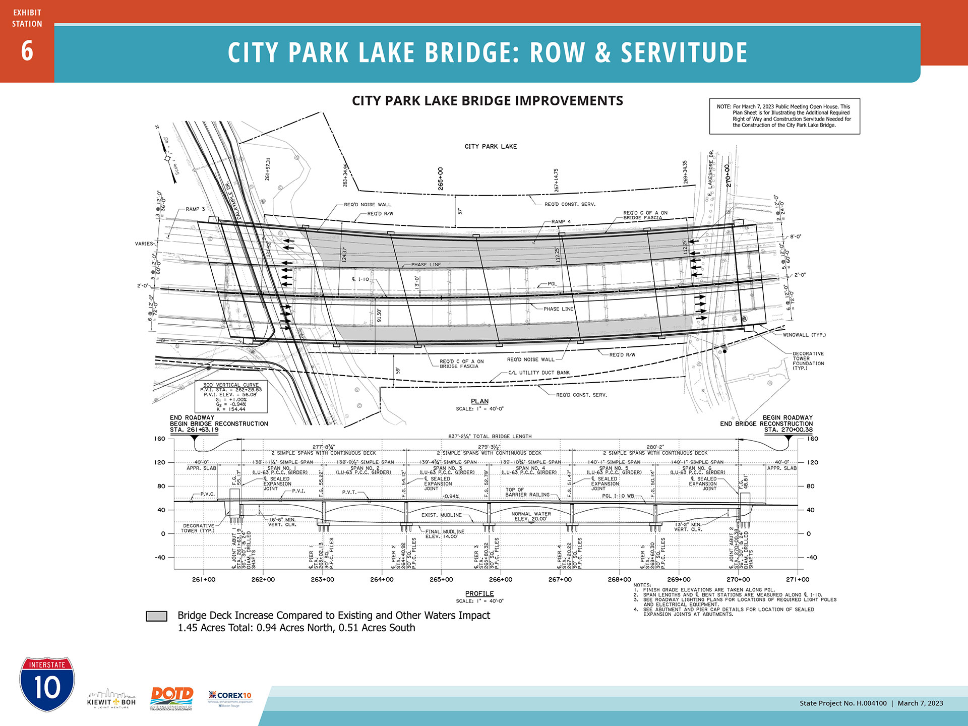
Station 6. City Park Lake Bridge Right-of-Way and Servitude
The project contractor has determined that additional area is needed to provide equipment and materials to access to I-10 where it crosses City Park Lake. The lake is owned by East Baton Rouge City-Parish. This exhibit identifies a need for purchase of additional right of way and construction servitude from the City-Parish across City Park Lake and shoreline.
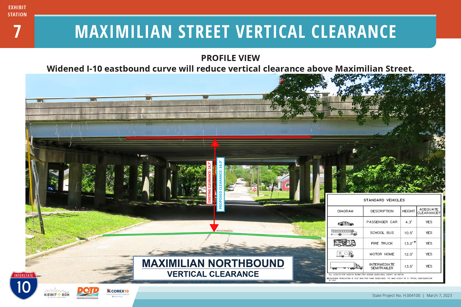
In downtown Baton Rouge I-10 crosses several neighborhood streets between the Mississippi River Bridge and the juncture with I-110. One of these is Maximilian Street, which because of topography rises beneath the interstate as one travels Maximilian from north to south. A widening of elevated I-10 above Maximilian will cause a loss of approximately 7 inches of vertical clearance for vehicles traveling Maximilian Street. In the NEPA phase, it was anticipated that Maximilian Street would be lowered in order to maintain the existing vertical clearance. However, during survey and design it was discovered that numerous utilities would need to be relocated. Therefore, the future condition will be 14 feet of clearance above Maximilian which is sufficient for most vehicles. The City Parish of Baton Rouge has concurred with this vertical clearance of 14 feet.
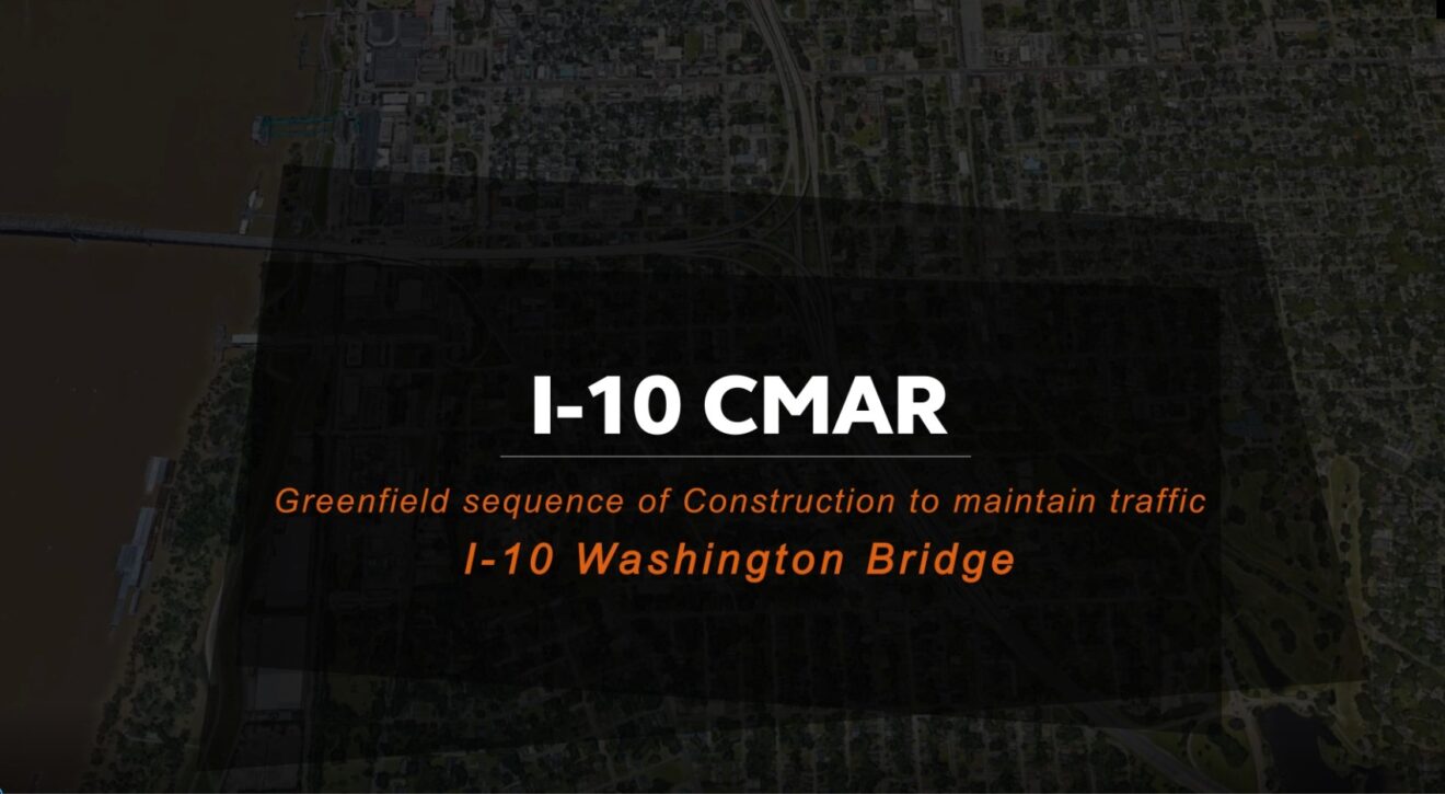
Station 8. Construction Sequence Visualization Video
Exhibited at the open house event on a TV screen was a narrated, animated video describing the sequence of reconstruction of the interstate through Baton Rouge. It focuses on conditions at a specific position along the corridor: where I-10 crosses Louise Street.
Transcript
Greenfield Sequence of Construction to Maintain Traffic I-10 Washington Bridge Area Created 2022 by Arcadis
This visualization of the greenfield approach will be centered around the Louise Street area, and one of the main benefits of the greenfield approach is that it limits the temporary widening and throwaway widening to only one side. On this approach, we’re going to be using the I-10 westbound side in phase one. Temporary widening will be constructed along I-10 westbound. After that is complete, traffic will be shifted to where both directions of I-10 travel will be on the westbound side. This allows the complete reconstruction of I-10 eastbound. Now you’ll note the substructure locations for the existing substructure will be avoided by the new substructure. And in fact, we’re going to increase the span length to really reduce the visual clutter of substructure by two thirds. In phase three, both directions of traffic will be shifted to the eastbound side and the westbound reconstruction will occur. Now, I’d also like to note that because of this approach, we are able to build each direction in only one stage that minimizes all construction joints and really simplifies the construction. Here’s your final layout. Along with auxiliary lanes and off ramps. Let’s take a look from the side. Now underneath, you’ll notice that the span lengths have been increased dramatically and that the visual clutter has been reduced. This will allow for the proposed greenway to come in, and we’re also able to better do architectural enhancements on these columns. It can result in a much better finished product for the community.
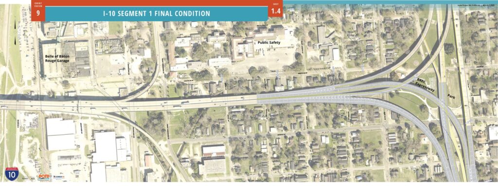
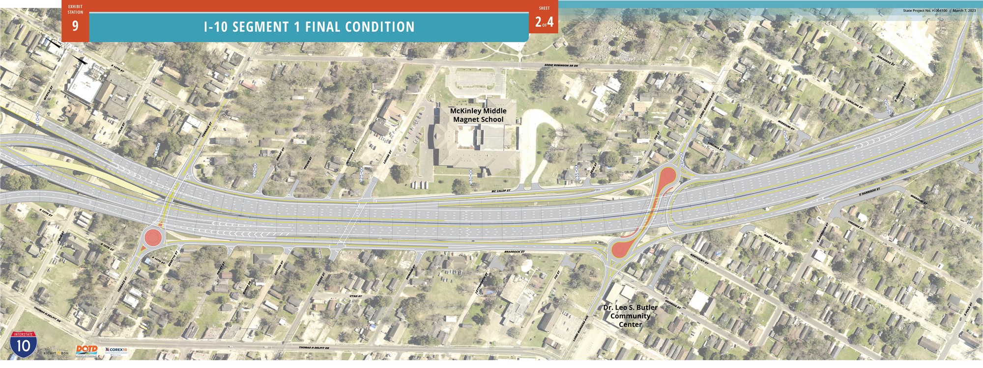
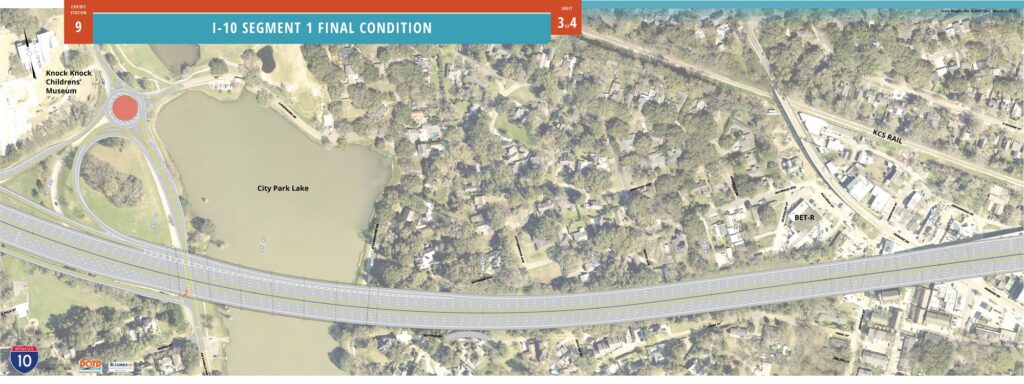
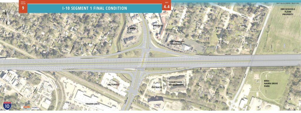
Station 9. Segment 1 Final Condition Plans
Across the center of the exhibit hall tables were arranged upon which a set of four drawings were rolled out, depicting the future, final condition of Segment 1. This plan view assists the public in understanding the number and position of travel lanes, of exit and on-ramps, and of properties located nearby. The four drawings below are displayed in order of west to east.
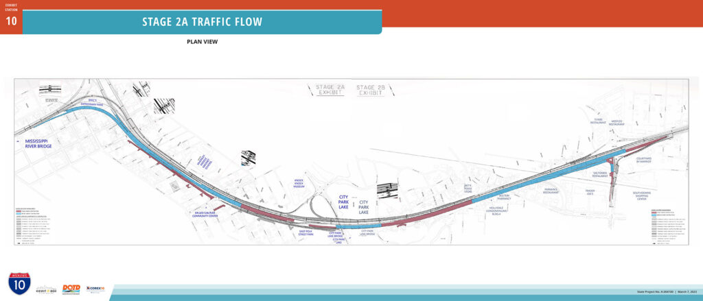
During Stage 2 of I-10 Segment 1, the interstate mainline will lose one lane of flow in the westbound direction from Acadian Thruway to Dalrymple Drive, and in the eastbound direction from the I-110/I-10 Interchange to Acadian Thruway for a duration of 12 to 14 months. This exhibit displays the areas of construction activity and available travel lanes on I-10 through the corridor during Stage 2.
With the intention of easing traffic congestion during Stage 2 of construction, DOTD, the project team and partner entities including the City of Baton Rouge – Parish of East Baton Rouge are planning and implementing numerous improvements and strategies aimed at mitigating traffic impacts. Station 11 offered ten exhibits describing these mitigation strategies as follows.
A task force comprised of regional first responders, law enforcement and others are collaborating to develop plans for managing traffic incidents within the project corridor for the duration of construction. The corridor is divided into zones, staging areas identified for dedicated response teams, and routes and methods of vehicle recovery are being determined. Particular attention is given to construction Stage 2 where the number of I-10 through-lanes are reduced by one in each direction.
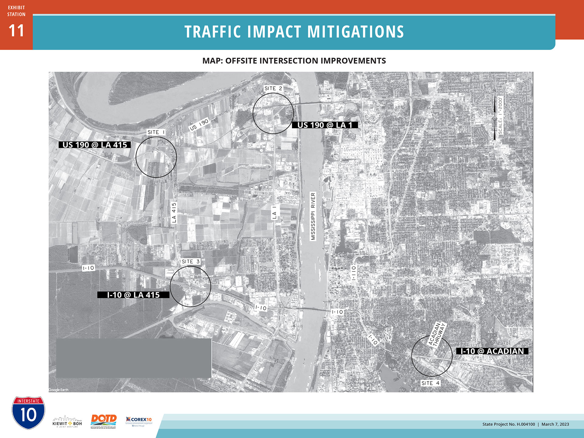
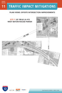
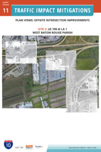
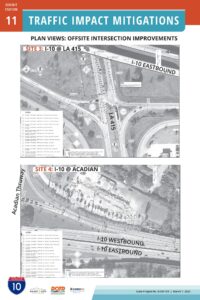
Offsite Intersection Improvements
Intersections of highways at four locations in our region have been identified by project engineers as benefiting from improvements to lanes, striping, and signal improvements. These improvements will increase the throughput of vehicles on these alternate routes and improve safety at these intersections. Three of the four are located in West Baton Rouge Parish, and one is in East Baton Rouge Parish.
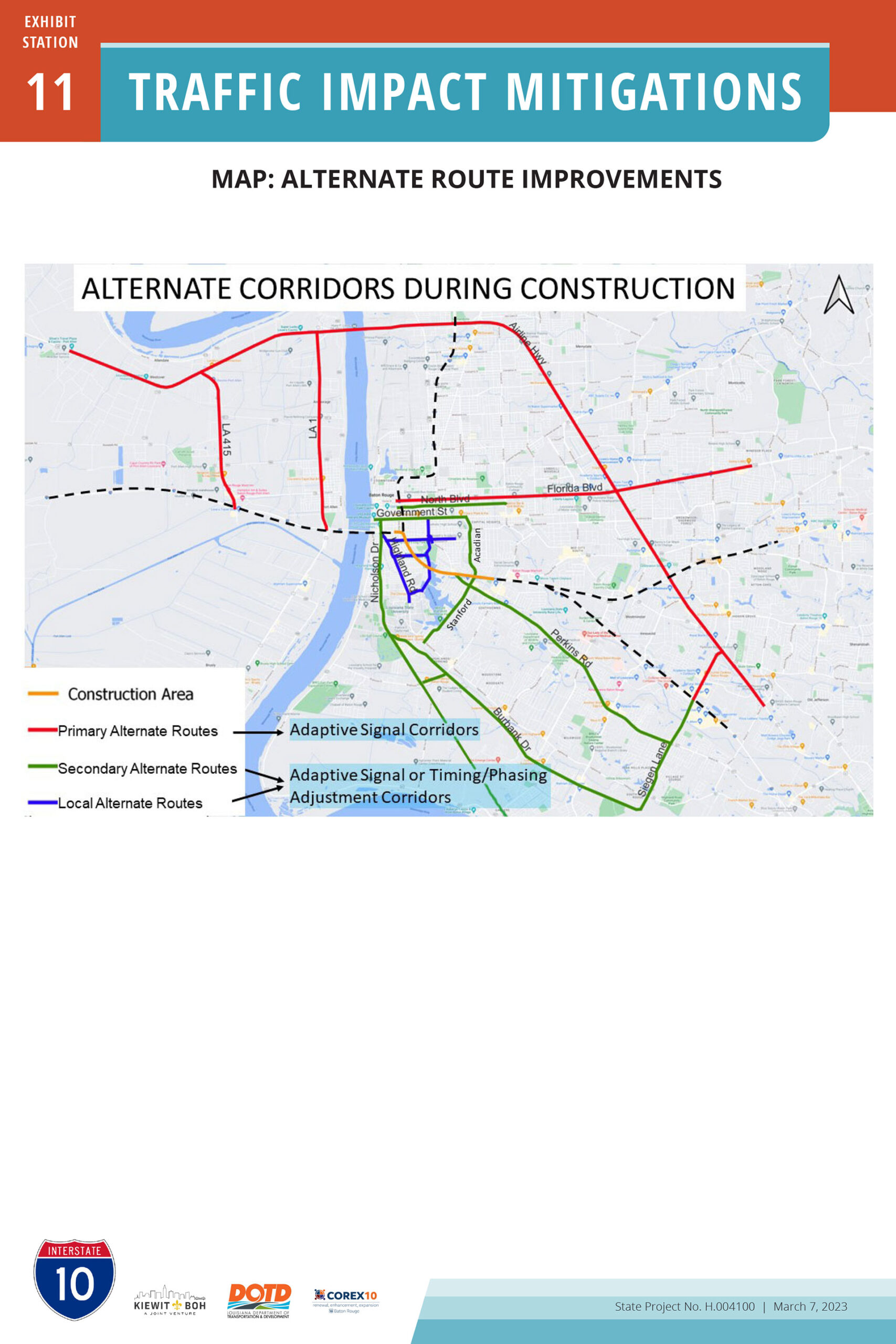
Alternate Route Improvements
In addition to the above four offsite intersections, improvements are recommended for other key corridors in the Baton Rouge region as illustrated on the map below. Corridor colors reflect the capacity and priority of these routes, as indicated on the map legend.
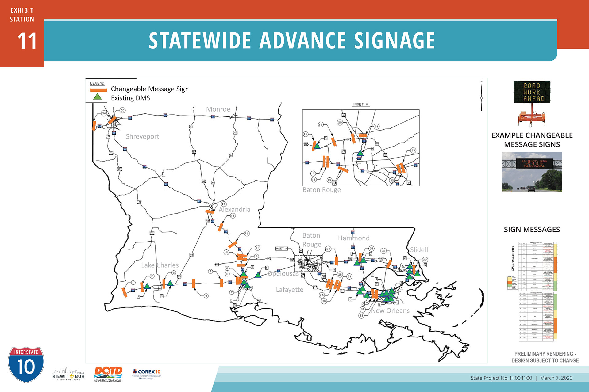
Statewide Advance Signage
A network of Changeable Message Signs numbering 33 or more are slated for deployment along interstate corridors across Louisiana to inform motorists of construction activity in the Capitol region and to recommend alternate routes. Greeting drivers entering Louisiana from adjacent states, additional signs will be positioned at intervals along I-10, I-12 and I-49 to repeat the message or provide additional information.
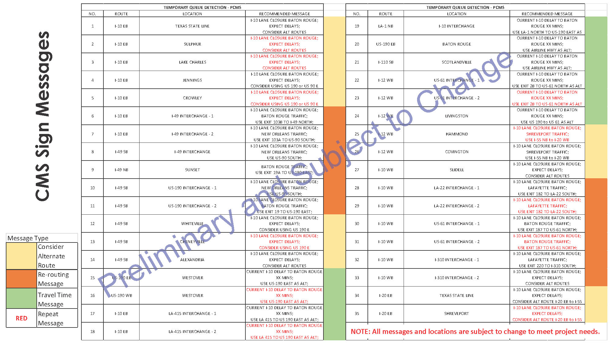
Below is an addendum to the above exhibit. Preliminary sign messages in the table on the exhibit proved difficult to read. Below is an enlargement of this data. Note that all information is preliminary and subject to change to suite project needs.
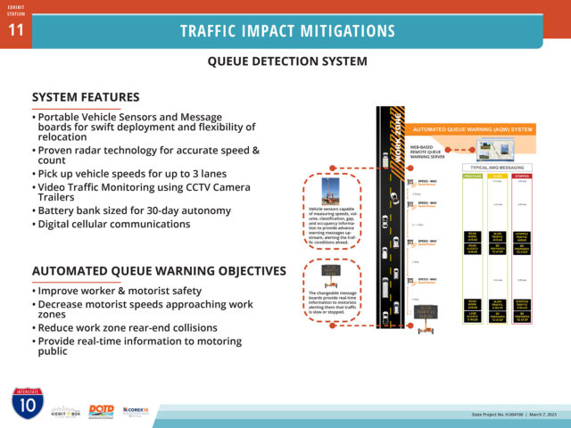
The I-10 contractor will deploy an automated Queue Detection System which monitors any buildup of vehicles approaching the construction zone and tracks their speed. This information is used programmatically to modify messages on Changeable Message Signs.
The I-10 BR project seeks to implement Context Sensitive Solutions (CSS) amenities which were identified and approved by the Federal Highway Administration (FHWA) during the environmental phase of this project. CSS is a component of FHWA’s nation-wide Community Connections program which seeks to restore connectivity between neighborhoods and communities split by transportation infrastructure in years past. In Segment 1 of this I-10 widening project there are three areas of CSS plans exhibited during the March 7, 2023 Open House. Noise walls lining the interstate corridor are a fourth component of the Context Sensitive Solutions palette. From west to east the Segment 1 CSS plans are:
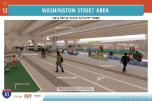
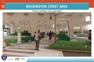
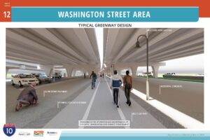
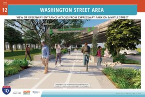
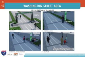
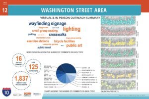
Washington Street Area (Lorri Burgess Avenue)
Key features of the CSS plan for the corridor through Old South Baton Rouge crossing E. Washington Street (now Lorri Burgess Avenue) include a multiuse path, seating and activity areas, restored structured parking, safety and aesthetic lighting, and limited landscaping with concentrations at cross-street nodes.
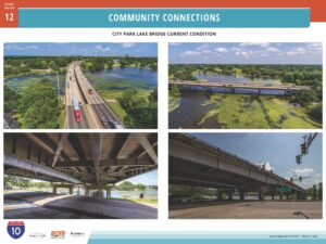
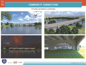
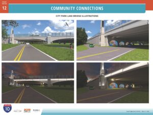
Interstate 10’s crossing of City Park Lake in Baton Rouge will be highlighted through these CSS plans for an architecturally enhanced “signature feature” bridge. Elements of the bridge design include corner towers, arches, art deco styled bas-relief responding to the Louisiana State Capitol and State symbols, decorative and safety illumination, and clear acrylic noise walls preserving views across the lake.
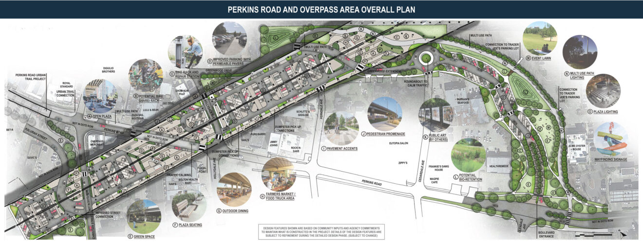
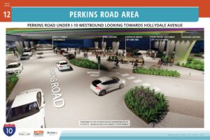
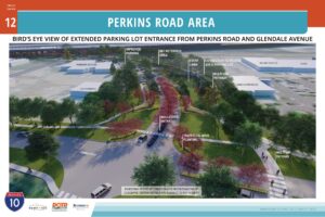
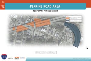
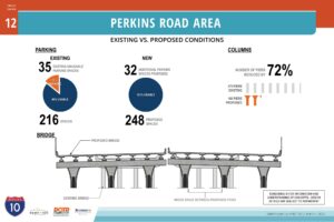
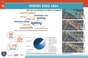
Interstate 10’s crossing of Perkins Road occurs at an active commercial and entertainment district. The CSS plan for this area seeks to provide needed customer parking more safely and organized than the current gravel lot condition. A multi-use path, increased connectivity of surface streets, pedestrian amenities, aesthetic and safety lighting, and limited landscaping are primary components of the plan.
Master plan of Context Sensitive Solutions improvements recommended for the I-10 at Perkins Road area.