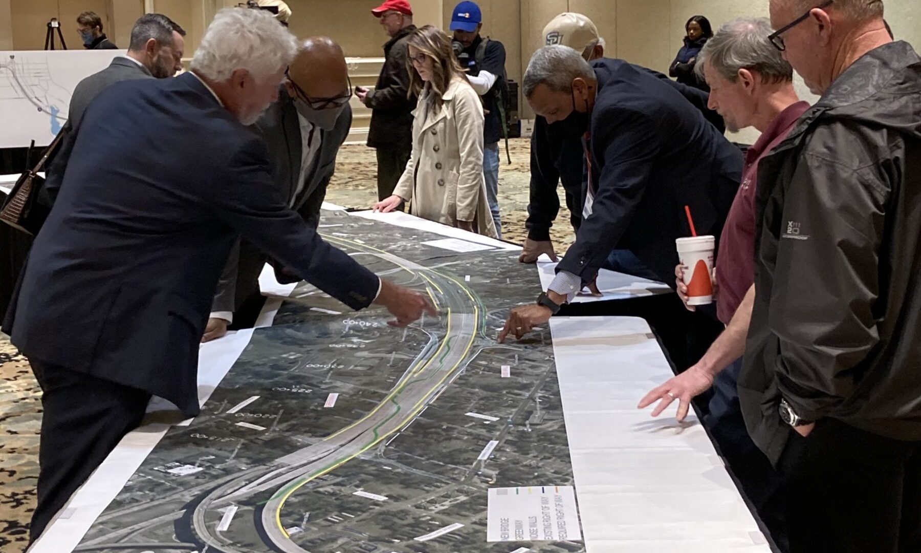
During February of 2022 two events were held where the public was invited to learn about the I-10 widening project through Baton Rouge. Numerous exhibits were on display and are provided below in digital format. The open house style events were:
Tuesday, February 8, 2022
5:30 p.m. to 7:30 p.m.
Crowne Plaza Hotel Ballroom
4728 Constitution Ave. | Baton Rouge, LA 70808
Thursday, February 17, 2022
5:30 p.m. to 7:30 p.m.
Dr. Leo S. Butler Community Center
950 E. Washington St. | Baton Rouge, LA 70802
The exhibits displayed at the above events are grouped into the categories of Interstate Corridor Plans, Interstate Noise Wall Options, Segment 1 Scope and Schedule, or Context Sensitive Solutions Commitments. There were two overarching messages about the project:
-
- The length of the corridor identified as Segment 1 is being extended further east to include the Acadian Thruway interchange which will cause the start date of construction in the vicinity of Perkins Road to be years sooner than previously messaged.
- Several options for material, color and design enhancements of interstate noise walls are presented for inspection and preference polling.
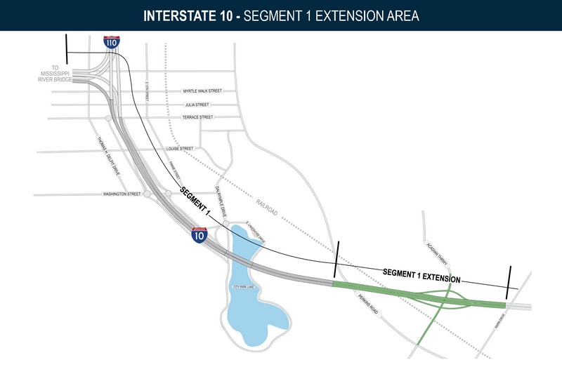
Segment 1 Extension
The overall interstate widening and improvements project [State Project No. H.004100.5] corridor extends from the LA 415 interchange in West Baton Rouge Parish eastward past the I-10/12 split to Essen Lane in East Baton Rouge Parish, excluding the Horace Wilkinson Mississippi River Bridge which is not proposed to be widened. The corridor is further categorized as Phase I: W. of Washington St. to Essen Lane and Phase II: LA 415 to W. of Washington St. Within Phase I, Segment 1 is identified as the initial area of construction work and it originally extended from west of Washington Street across City Park Lake to a point approaching Perkins Road. The innovative CMAR project delivery process has identified efficiencies in construction and considerable savings of time and money by extending the Segment 1 work area further east to include Perkins overpass and the Acadian Thruway interchange. DOTD and its contractor forecast a construction duration of four years for this extended Segment 1, a savings of four to six years from previous estimates of two concurrent construction segments.
Noise Walls
The Federal Highway Administration, in conjunction with LA DOTD have concluded based on noise studies and analysis completed in previous project stages, that both sides of the new I-10 through Baton Rouge should be lined with noise walls. The new proposed noise walls will be of a lighter weight material and will be mounted directly on the interstate structure, adjacent to the road shoulders. A variety of acrylic and aluminum panel options are presented for review and preference polling. DOTD will retain scenic views of Baton Rouge from the bridge crossing City Park Lake by using the transparent acrylic panels. The video below illustrates what these acrylic panels might look like from a driver’s perspective on the new interstate.
Exhibits From the Open House Events
The following exhibits were on display at two open house events by the project team. Thumbnail images link to larger images, and a link to downloadable PDF editions is provided for each.
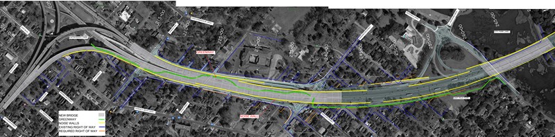
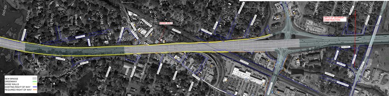
Interstate Corridor Plans
These plans overlaying aerial photography show the locations of roadway improvements, existing and newly acquired public right-of-way, and the position of future noise walls.
Interstate Noise Wall Options
The new interstate will be lined with noise walls composed of acrylic or aluminum panels. Options include transparent, frosted acrylic, opaque acrylic, or corrugated aluminum. Artist’s renderings, photos of installed walls, a driver’s eye video, and material samples of products from the manufacturer were on display. The corridor is divided into five areas, and preference polling is provided for four of the five.
Segment 1 Scope and Schedule
The following exhibits interpret the construction sequence for extended Segment 1, including forecast start and duration periods. Travel lanes will be shifted during the construction process.
Context Sensitive Solutions Commitments
During preceding environmental study and review phases of the project the DOTD met with community groups and identified several key Context Sensitive Solutions or enhancements to local streets or lands within the interstate right-of-way. Many were presented in the Finding of No Significant Impact (FONSI) document and remain as commitments to the community intended to mitigate adverse impacts of the interstate system. Noise walls are one of these commitments, and more are represented in the illustrations below. Future community meetings will focus on further identifying and refining the design and proposed implementation of these CSS enhancements.
Drainage Outfall Servitude Exhibit
The results of the preliminary drainage design process determined that an existing outfall pipe was inadequate and that a larger outfall pipe was required inside a new drainage servitude within Brooks Park. The drainage will flow through a pipe on the southeast side of McKinley Middle Magnet School bus drop-off area to an existing drainage swale along the rear of Brooks Park. Brooks Park is owned by BREC and/or the City-Parish of East Baton Rouge. A de minimis impact determination was made for this additional drainage servitude measuring approximately 55’ by 50’ to be acquired from BREC’s Brooks Park. A graphic detailing the drainage and location was presented at the February 17, 2022 event at Dr. Leo Butler Community Center. Street level snapshots of the site have been provided below as an aid to orient the viewer.
If you have a comment about this proposed drainage outfall servitude please access the Submit a Comment page and mention “drainage servitude” in your comment. Comments regarding the drainage servitude will be accepted until Friday, March 11, 2022.