Updates
Segment 1 Design Modifications or Refinements
Pictured is an east-facing view of I-10 in Baton Rouge from above Expressway Park. Myrtle Avenue is the surface street across the middle of the image. This bird’s-eye view shows a portion of the I-10 Segment 1 project area described below.
Of note, during the course of this project, a key local street within the project study area was renamed by local government from E. Washington Street to Lorri Burgess Avenue in honor of the first female African American Mayor Pro Tempore for the City of Baton Rouge and Parish of East Baton Rouge. The street renamed Lorri Burgess Avenue extends from Dalrymple Drive to Highland Road. Older content on this website such as the project background and early exhibits may reference this local road as E. Washington Street.
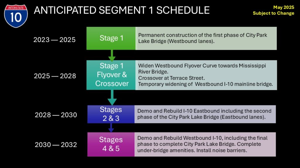
Segment 1 Anticipated Schedule
Segment 1 of this project is defined to extend from W. of Washington St. (Lorri Burgess Ave.) to the Perkins Road On/Off ramps. The schedule below describes anticipated timeframes for accomplishing this work.
Design Modifications for I-10 Segment 1 (2023)
Design modifications to the I-10 Widening project are necessary within Segment 1, which extends from W. of Washington St. (Lorri Burgess Ave.) to the Perkins Road On/Off ramps. Presented is a description of design modifications for inclusion in the project documentation required by the National Environmental Policy Act (NEPA) which were displayed publicly on March 7, 2023 at a Public Meeting:
-
- Widening of the I-10 westbound “flyover” curve towards the Mississippi River bridge at the I-110 Interchange is to facilitate Maintenance of Traffic from the I-10/I-110 Interchange to the Perkins Road On/Off ramps and will be constructed to current standards.
- Right-of-Way impacts to several units at the Hollydale Condominiums near the Perkins overpass.
- Slightly reduced vertical clearance above Maximillian Street below I-10 to mitigate for utility relocation.
- The traffic mitigation strategy of implementing Adaptive Signal Timings and Re-Timing on Alternate Routes and Statewide Advanced Signing.
Explanations of the above, with associated graphics may be viewed on the March 7, 2023 Public Open House documentation page of this website. Several design modifications presented in 2023 are no longer being considered. They are:
- Maintaining 6 lanes during construction – The March 2023 concept recommended reduction of I-10 through-lanes from 6 to 4 for approximately 18 months between I-110 and Acadian Thruway to expedite construction. After public input, DOTD decided 6 through-lanes will be preserved (temporary nightly and weekend closures may be possible) for the duration of the project. DOTD intends to provide a 6-lane Maintenance of Traffic Plan on I-10 during construction of Segment 1 from the I-10/I-110 Interchange to the Perkins Road On/Off Ramps.
- Braided Ramps between Acadian and College – The Segment 1 project ends at the Perkins Road On/Off Ramps. Since the braided ramps are east of the Perkins Road Ramps (located between Acadian Thwy. and College Dr.), they are excluded from the current project scope. Consideration for their inclusion in the overall project may occur in a future phase of design and construction.
- The Traffic Mitigation strategy of Offsite Intersection Improvements – The DOTD plans to provide a 6-lane Maintenance of Traffic plan on I-10 between the I-10/I-110 Interchange and Perkins Road ramps during interstate construction. Traffic analysis results indicate that the criteria for signal warrants at these offsite locations are not satisfied for these intersection improvements. Consequently, offsite improvements will be excluded from the project.
- The Final Condition Plans displayed March 7, 2023 are no longer valid. Please see the Design Refinements to Segment 1 described below.
Design Refinements and Additional Traffic Mitigation Strategy (2025)
May 2025
As additional study, design and agency review occurred since 2023, two design refinements are proposed for I-10 Segment 1 which extends from W. of Washington St. (Lorri Burgess Ave.) eastward to the Perkins Road On/Off Ramps. Also included as part of a NEPA Reevaluation Report are adjustments to noise barriers and an additional traffic mitigation strategy.
Refinements
1. Refinements to I-10 Eastbound
2. Refinements to I-10 Westbound
Noise Barriers
3. Adjustments to Noise Barriers related to the above design refinements
Additional Traffic Mitigation Strategy
4. Traffic Mitigation strategies to improve and promote Available Routes serving Adjacent Neighborhoods.
Each are described in greater detail below.
I-10 Eastbound Design Refinements
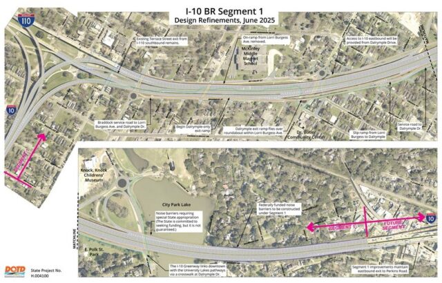
The future condition will not feature an exit to Washington Street (Lorri Burgess Ave.) Modern interstate design practices require greater separation between interchanges and exits for improved safety. The entrance to this exit is being shifted eastward, further away from the I-110 Interchange, and the lane will now pass over Lorri Burgess Avenue providing an exit to Dalrymple Drive. Motorists driving eastbound on I-10 will be able to exit at Nicholson Drive / Highland Road and Dalrymple Drive. Design refinements to eastbound I-10 also resulted in the need for acquisition of additional right of way. Refer to the “Additional Required Right-of-Way” section below for more information.
Additional Required Right-of-Way (ROW)
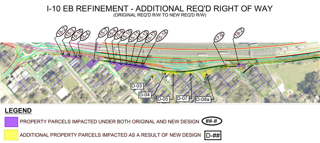
Design refinements to the eastbound lanes of I-10, including the exit to Dalrymple Drive and the bike & pedestrian greenway linking Expressway Park to Dalrymple Drive, resulted in the need to acquire property as State Right-of-Way. Letters were mailed to property owners offering in-person meetings at DOTD to begin discussing the State’s ROW acquisition process following DOTD’s “Acquisition of Right-of-Way and Relocation Assistance” brochure. Below is a map and list of these properties.
| Exhibit ID. (1) | Location | Date Certified Letter (2) Mailed to Owner |
Meeting Date | Area (SQ. FT) (Exist R/W to New R/W) |
|---|---|---|---|---|
| D-03 | 2002 Virginia St. | 10/15/2024 | 10/30/2024 | 130.5 |
| D-04 | 2019 Virginia St. | 10/10/2024 | 10/31/2024 | 1,013.8 |
| D-05 | 2041 Virginia St. | 10/15/2024 (returned undeliverable) |
Site visit 11/6/2024 found home vacant |
847.8 |
| D-07 | 2036 Missouri St. | 10/10/2024 | 10/24/2024 | 584.5 |
| D-08a | Parcel ID: 790087 | 10/10/2024 (returned undeliverable) |
Site visit 11/6/2024 found irregular, vacant parcel |
2,000.0 |
| TOTAL AREA: | 4,576.6 (SQ. FT) | |||
| TOTAL AREA: | 0.11 (ACRE) |
(1) Exhibit ID corresponds to callout labels on map above.
(2) Letters were posted Certified US Mail to property owner addresses on file with the East Baton Rouge Parish Assessor.
I-10 Westbound Design Refinements
The westbound interstate on-ramp from Lorri Burgess Avenue will be removed for safety reasons. In the current condition, conflict occurs when vehicles attempt to quickly merge across three lanes of northbound I-110 traffic to access the Mississippi River Bridge heading west on I-10. Because the on-ramp cannot be redesigned and reconstructed without significant right-of-way impacts, it is being removed from the final design. In the refined design, motorists may use the Dalrymple at E. Lakeshore access ramp to proceed either west or east on I-10, and also to access northbound I-110.
Future Conditions Exhibits
Western portion / Segment 1
Eastern portion / Future Segment
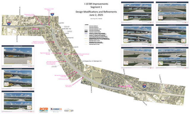
A detailed plan view (featured below) with associated street view illustrations is available here.
And as depicted below, a “juxtaposed” version of the Segment 1 plan where you may compare proposed plans with the current condition may be viewed here.
Adjustments to Noise Barriers
A noise analysis was performed for the design refinement geometry and to current FHWA regulations. Noise impacts occur along the alignment in East Baton Rouge Parish. To mitigate these impacts, federally funded noise barriers are proposed in some locations according to DOTD policy. The State is committed to seek a special appropriation for noise barriers that do not qualify for federal funding. This commitment is not a guarantee that noise barriers will be funded. Locations of federal and potential state-funded noise barriers are identified on the above future condition exhibits.
Additional Traffic Mitigation Strategy
Traffic mitigation strategies are proposed to improve and promote available routes serving neighborhoods adjacent to I-10 Segment 1.
- During construction, ramp closures will occur.
- As entrance and exit ramps are closed, residents and businesses will be provided information through public outreach from the contractor providing notice of the pending change and describing available routes which serve neighborhoods along the project corridor.
- Through robust public outreach by the contractor, motorists will be provided information about ramp closures and alternate routes so that they may make informed decisions on rerouting necessary to reach desired destinations.
Street Level Views
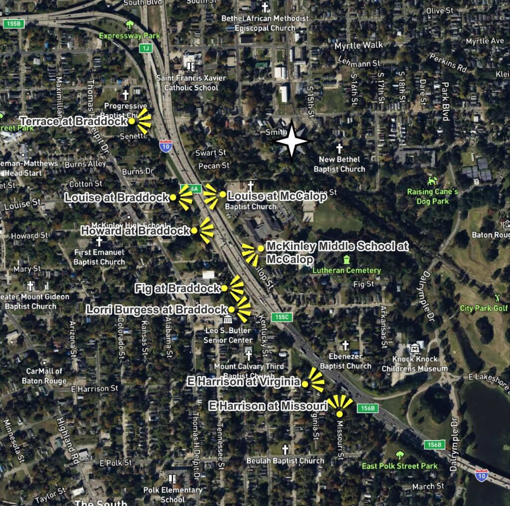
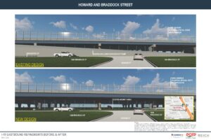
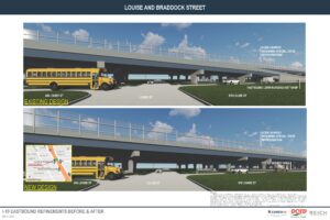
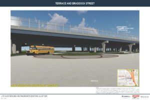
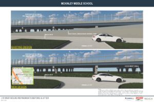
Artist’s renderings have been prepared displaying what the future condition of the I-10 / I-110 interstate might look like after the above-described design refinements are implemented. The yellow icons on the map below denote the position of the observer on a local city street facing towards the interstate.
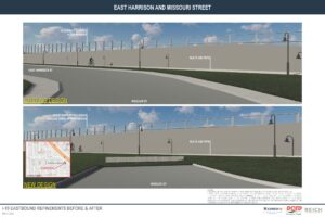
The images below correspond to each of the above locations.
Community Impact Assessment Technical Memorandum
A community impact assessment was developed to evaluate how the proposed project may affect the people and communities within the project area. This analysis is a key component of NEPA’s broader directive to consider not only environmental impacts, but also the human environment, including community cohesion, economic vitality, access to services, and population demographics. Title VI of the Civil Rights Act of 1964, prohibits discrimination based upon race, color, and national origin. Specifically, 42 USC 2000d states that “No person in the United States shall, on the ground of race, color, or national origin, be excluded from participation in, be denied the benefits of, or be subjected to discrimination under any program or activity receiving Federal financial assistance”.
Section 4(f) Evaluation and Section 106 Coordination
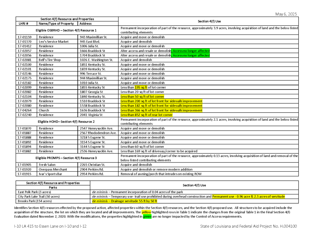
A Section 4(f) evaluation was developed in 2020, and a revision was developed in March 2025. During design, it was determined that modifications were necessary. This is not unusual for a project this size. The proposed modifications (highlighted on the table below) add an additional 0.44 acres of required right of way from an eligible historic district, which is the reason for the revision. A 4(f) analysis was performed.
Consultation with the LA State Historic Preservation Officer (SHPO) in compliance with Section 106 of the National Historic Preservation Act was also necessary due to the design modifications. The SHPO is the official with jurisdiction regarding the affected historic districts. DOTD, in conjunction with FHWA, determined that the revised scope of work for the project would not add additional adverse effects to historic properties than what has already been recognized through previous consultations. DOTD sent a letter to the SHPO on December 24, 2024 requesting concurrence with the determination that the modifications will not adversely affect additional historic properties and SHPO concurred on January 10, 2025.
